Despite the Hollywood depictions of gambling and gun-slinging, Tombstone was a mining town. Another post on this site describes the Tombstone Mining District, an area of about 100 square miles with Tombstone near the northwest corner. The district had more than 100 active mines, but the most productive ones were in or near Tombstone. The Epitaph reported some interesting numbers, "…mining bullion from November 1, 1881, to January 1882 also indicated Tombstone had done well. The output for the Toughnut group, which consisted of the Contention or Western, Grand Central, Head Center, Vizina, Ingersoll, Sunset, and several other underdeveloped mines, was $6,488,361." The Grand Central employed 90 men, the Contention 102, Tombstone Mine 200, and the Vizina 50. The number of men employed at the principal mines throughout the Tombstone area totaled 637. That did not include approximately one hundred more who did contract and assessment work independently. (These numbers came from Sherry Monahan; Tombstone's Silver Mines and Golden Saloons; ASIN: B004IYKVSK, pages 27 and 30.)
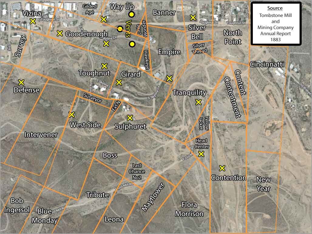
The map above locates mines and claims that were in or near Tombstone. The yellow lines indicate the edges of the various mine claims. Mine shafts are marked with an "X" and three air vents are marked with a yellow dot.
- The source for this map was the Tombstone Mill and Mining Company Annual Report published in March 1883. The claim locations and names would have been accurate as of the day that report was published.
- After the 1883 annual report was published, many of the mines and claims were purchased and consolidated into larger companies, so a few of the mines on this map would not have existed even a year later.
- It sometimes surprises guests who are visiting Tombstone, but there were mine heads in the heart of Tombstone, not just out in the desert. An 1884 observer captured the effect: "The mining claims run under the city itself: the shafts, the hoist works, and heaps of extracted ore of the Vizina, the Gilded Age, the Mountain Maid, and other mines open strangely in the very midst of the buildings. This circumstance has given rise to disputes of ownership, so that whoever would be safe purchases all the conflicting titles both above ground and below."
- The Goodenough Mine had two main workings that are described in the Annual Report: "This has been the most productive property of the Company, having yielded about 41,500 tons of rich ore since it was first opened in 1879. The ore is found in two separate collections of ore bodies, one at each end of the claim, that at the East end being known as the Main works, and that at the West end being called the Combination and Number Six. In each place there were four large bonanzas."
- The main shaft for the Vizina Mine was located near where the city library is located today.
- The main shaft for the Mountain Maid Mine was located near the present "Four Deuces Saloon." The Earp brothers were part owners of the First North Extension of the Mountain Maid Mine.
- The main shaft of the Way Up Mine was located near where the city’s heavy equipment lot is located today. This lot is sometimes called the "lower lot" and guests often use it for RV parking during busy weekends. Very few people realize that the main Way Up shaft is visible under a black steel grate that looks like a storm drain cover near the edge of the parking lot. The Way Up had a complicated relationship with the neighboring Good Enough Mine. Under the federal apex law, the owner of whatever claim a vein’s apex surfaced on had the right to follow that vein downward even if it ran beneath a neighboring claim. When the Way Up’s owners argued that the Good Enough ore body was actually their vein at depth, the dispute went to trial in December 1881. After two years of appeals, the Arizona Territory Supreme Court affirmed a ruling for the Way Up in 1883 — though the Good Enough ultimately bought them out.
- The largest producing mine in the district was the Grand Central. It was located immediately south of the Contention, just off this map. At its 1881 peak the Grand Central ran ore averaging $80–$100 per ton through a 30-stamp mill on the San Pedro River, with a main shaft 500 feet deep and three working levels. By late 1883 it had become one of the town's landmarks. The diarist George Parsons recorded visiting it that October with friends: "Went through the Grand Central Mine this A.M. with Arthur, John and Sam, and later through Girard Mill" — a routine civic outing for a long-time Tombstone resident.
- Three air vents are indicated on the map. While all mines had several vents, these three are covered with a metal "tent" that are easy to see from one of the roads.
Sources
- Sherry Monahan, Tombstone's Silver Mines and Golden Saloons (ASIN: B004IYKVSK). Source for production figures (November 1881 to January 1882) and mine workforce numbers.
- Tombstone Mill and Mining Company, Annual Report (March 1883). Source for the mine claims map and the Good Enough Mine production figures.
- Tombstone Restoration Commission, Plan for the Creation of a Historic Environment in Tombstone, Arizona (1972), reprinting History of Arizona Territory (1884). Source for the mines-under-the-city description.
- Resources of Arizona (1881), Report to the Arizona Territorial Legislature. Source for Grand Central Mine individual data ($80–$100/ton, 30-stamp mill, 500-foot shaft).
- George W. Parsons, Journal, Volume 2 (June 28, 1882 – March 31, 1887), Arizona Historical Society. Source for the October 1883 Grand Central Mine visit.