Most folks know about the GoodEnough Silver Mine because of the tours, but Tombstone had many mines. This article describes the Tombstone Mining District, while another pinpoints some mining claims and shafts found near Tombstone's city.
Cochise County
In 1973, the Arizona Bureau of Geology and Mineral Technology published an "Index of Mining Properties in Cochise County." That report divides Cochise County into 18 different mining districts, as follows.
- California (Chirichua). In the modern Chiricahua Monument area near Willcox. The major producer was the mine at Galeyville, where lead and silver were mined. The total value of all ore extracted amounts to about $1.75M.
- Cochise. Near Benson, mainly north of the present-day I-10. Major metals were copper, lead, zinc, silver, and gold. In the early 1900s, it was a major tungsten producer. The total value of all production was over $32M.
- Dos Cabezas - Teviston. East of Willcox in the Dos Cabazes mountains. These are small mines producing copper, lead, zinc, silver, and some gold worth a total of $1.8M.
- Douglas (Ash Peak). This is a volcanic area and has had no major mining activity. It has produced some gypsum and volcanic cinder blocks used for construction.
- Dragoon. East of Benson in the north end of the Dragoon Mountains south of I-10. About the only major producer has been the Golden Rule (or Old Terrible) mine. It produced copper, lead, zinc, gold, and silver for a total value of $340,000.
- Huachuca Mountains. From Ft. Huachuca and south to Mexico. The district had only a few small mines that produced copper, lead, zinc, gold and silver worth a total of $140,000.
- Middle Pass. Gleeson road through the Dragoons. There were only a few small mines and they were worked for only a few years at a time. The district produced copper, lead, zinc, gold, and silver for a total production of $1.7M.
- Paul Spur. Tiny district south and east of Warren, near the border of Mexico west of Douglas. This district has no metal deposits and is noted only for Limestone operations.
- Pearce. East of the Dragoons, near Pearce, in the middle of the Sulphur Spring Valley. The Commonwealth mine is responsible for nearly all activity in the district. It produced copper, lead, silver, and gold for a total value of $10.6M.
- Peloncillo. Where I-10 crosses into New Mexico. This district has never been mined and only a few weak oxidized copper deposits have been found.
- Rucker Canyon. East of Elfrida, about half-way between AZ 191 and AZ 80. This district has produced only a few tons of metal ore and has never had any significant commercial mines.
- Swisshelm. East of Elfrida. Mines have produced copper, lead, zinc, silver, and gold worth a total of $2M.
- Tombstone. (See below)
- Turquoise. East of the Dragoons, near Elfrida. Indians extracted turquois from this area long before white prospectors discovered silver in the 1850s. The major producers were Gleeson (silver) and Courtland (copper). The major metals were copper, lead, zinc, gold, and silver for a total value of $14M. Additionally, there has been an unknown quantity of gem quality turquois extracted.
- Warren (Bisbee). This is, by far, the most productive area in Cochise County. The annual totals produced from this district has always exceeded the combined total of all other districts in Cochise County. The district has had both underground and pit mining operations. The major products have been copper, lead, zinc, gold, and silver. Additionally, manganese was shipped out in war years. The total value of this district's production exceeds $1.9B.
- Whetstone. The western edge of Cochise County, near the modern town of Whetstone. Mines in this area have been relatively small and shallow, yielding copper, silver, and gold. The total value of the district has been $14,000. Additionally, about 47 tons of low-grade uranium ore was shipped out of this district.
- Winchester. North of Benson and near the western edge of Cochise County. This district has had very little mining production.
- Yellowstone. North of I-10 east of Willcox. There were unconfirmed reports of gold production in the 1880s but there has been no known mineral production since then.
Tombstone Mining District
Mining in Cochise County can be traced back as early as the 1860s, but continuous Indian raids and general lawlessness in the area stopped any significant mining efforts. Tombstone's first intense mining activity started in 1878 with Ed Schieffelin's discovery of the Tombstone claim. Shortly afterward, he staked out several claims, including the Good Enough, Lucky Cuss, and Tough Nut. The Tombstone Mining District was officially formed on April 5, 1878; all claims were held quietly without recording until April 9 to keep the find secret from competing prospectors.
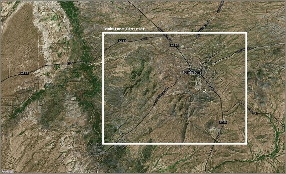
The map below highlights the boundary of what was considered the Tombstone Mining District. The city of Tombstone is near the center, but the district incorporates land to the San Pedro River on the west. The northwest corner of the district includes the former railhead at Fairbank, and the southwest corner includes the mill sites of Millville and Charleston.
The stakes in those claims could shift dramatically day by day. In April 1880, two years into the boom, the diarist George Parsons recorded a moment at one of his own small claims: "Down 22½ ft. now and have struck two veins of rich ore. Veins each side of shaft — and approaching. My 1/20 is worth $1,000 tonight. I would not take that but for money to run the matter." That same evening he dined with a visiting Russian mining engineer, A. Meyendorff, who had traveled through every major camp in the territory and declared Tombstone "the most promising camp of any today." In the spring of 1880, it was easy to believe.
The records for mineral production from those early years are fragmented and scattered among many governmental offices and several mining companies that no longer exist. However, the Index used for this post provides the most accurate estimate. The following is quoted from pages 12-13 of the Index.
"The first mineral location in the famous Tombstone district was made in 1857 but the rich silver deposits were not found and worked until after 1877. Development and mining proceeded rapidly and by 1890 over one-half of the total district production had been extracted. Since that time, up to about 1951, there was continuous operations although the yearly amounts extracted varied with silver prices and operational conditions. The major production period declined after uncontrollable flooding prevented deep development. Lead and manganese contributed to the total ore value extracted. A few small outlying mines have produced base metal ores with minor amounts of molybdenum, vanadium, scrap mica, and clay.
"Production figures for the Tombstone mining district before 1900 can only be estimated, but up through 1970 not less than 1.5 million tons of silver bearing ore, either with lead or manganese, was extracted. The yield would amount to some 1.5 thousand tons of copper, 22.5 thousand tons of lead, 590 tons of zinc, 240 thousand ounces of gold, and some 30 million ounces of silver. The total value of the production would exceed 38.8 million dollars. Besides the manganese-silver ore used as flux in the early days of the district, about 9,000 tons of manganese ore was shipped out during war years."
Finally, the following table lists the highest producing mines in the Tombstone District. Notice that many of the mines merged other existing mines together.

The Million Dollar Stope
The Good Enough Mine provides one of the district's more dramatic postscripts. In April 1907, an ice wagon was making its way down Toughnut Street when the horse pulling it stumbled. The driver jumped down to investigate and found himself standing at the edge of a large opening in the earth, with his horse and wagon seventy-five feet below. The stope of the Good Enough Mine had collapsed into a cavern 300 feet long, 200 feet wide, and 100 feet deep, with only a thin crust of earth between it and the street surface. Mine superintendent James Macia led the horse out through an underground passage several hundred feet from the cave-in site. The Good Enough had been one of the district's most productive mines; the collapse made visible just how thoroughly the ground beneath the town had been worked.
The hole became a tourist attraction known as the Million Dollar Stope and remained one of Tombstone's major draws until 1986, when it was filled in due to concerns about the stability of the surrounding old mine workings.
Sources
- Arizona Bureau of Geology and Mineral Technology, Index of Mining Properties in Cochise County (1973). Source for the 18-district breakdown of Cochise County mining properties and the Tombstone district production statistics.
- Tombstone Restoration Commission, Tombstone's Historic Locations (2008). Source for the 1907 Good Enough Mine stope collapse and the Million Dollar Stope history.
- Lonnie E. Underhill, ed., "The Tombstone Discovery: The Recollections of Ed Schieffelin and Richard Gird," Arizona and the West, vol. 21, no. 1 (Spring 1979), pp. 37–76. Source for the Tombstone Mining District formation date and claims recording timeline.
- George W. Parsons, Journal, Volume 1 (March 27, 1879 – June 27, 1882), Arizona Historical Society. Source for the April 1880 investor perspective and Meyendorff assessment.