Need
Mining in the Tombstone area began in 1878 and the town was founded the next year. In those early days, wagons with 20 horses or mules were used to get ore to the mills in Charleston, about eight miles away. All the food and merchandise needed by the miners, along with the materials needed to operate the mines, were brought in by wagons from Benson, where the nearest rail line was located. Also, a lot of people were traveling to Tombstone every day and they would come by stagecoach from Benson. A railroad was needed, but it would take more than two decades to realize that goal.
Plans
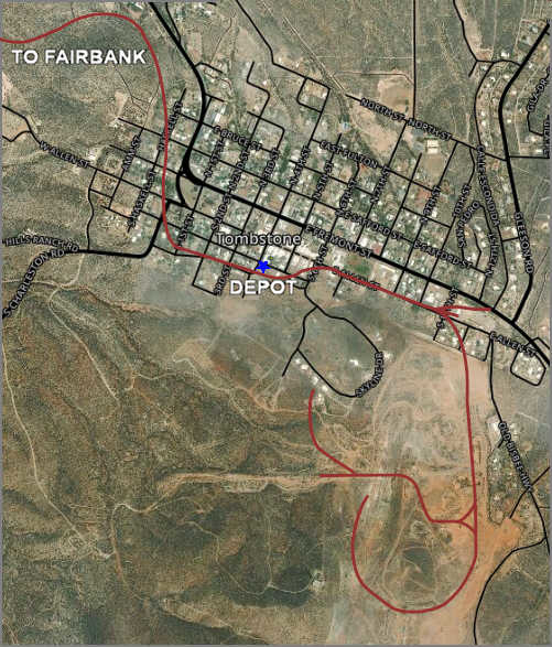
The first railroad into Tombstone was planned by the Arizona and Mexico Railroad and Telegraph Company in 1880. That route was to go from Benson to Charleston, then to Tombstone past the Lucky Cuss and Sulphuret mines and terminate near the Silver Belt mine. Unfortunately, that railroad never got beyond the initial planning phase. In 1881 Santa Fe railroad constructed a line from Benson to Contention on the San Pedro River, and regular runs started in 1882. That line eventually extended to Fairbank, where it turned west to Nogales and then into Mexico. In 1882, work began on a Tombstone branch planned to start at Fairbank and continue through Tombstone to Deming, New Mexico, but that work stopped without explanation. However, it could be because mining hit a few rough snags and the future of Tombstone was somewhat uncertain. The image below shows the route that that railroad eventually took in Tombstone. For reference, the highway to Benson, Rte 80, is the first thick black line that enters at the top of the map.

Building
In 1888 the Arizona and South Eastern Railroad Company began building a line from Fairbank to Bisbee for the copper mines. However, they selected a route along the San Pedro River that excluded Tombstone. Eventually, that railroad would run from Benson to El Paso and become the El Paso and South Western (EP&SW). The EP&SW started a line from Fairbank to Tombstone on March 9, 1903, and on April 12, 1903, the first train rolled into Tombstone.

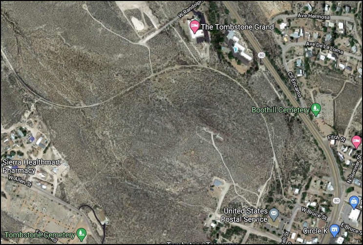
The 1903 rail line started in Fairbank and followed Walnut Gulch, a tributary of the San Pedro River, east for six miles, then climbed out of the ravine before circling Comstock Hill and entering town near the current post office. After passing behind the courthouse, it reached the depot along Toughnut Street. The rails then ran on into the mining area south and east of town, circling the Grand Central and Contention mines and spurs to several other mines. Since Tombstone was never a "travel through" destination, the trains had to turn around and return, undoubtedly using the wye near the Grand Central mine. The image shows what is left of the original railroad grade. An extended, sweeping circle goes around Comstock Hill in the center of the image (that hill is usually called the "T" mountain due to the large "T" near its peak). The group of buildings at the top center of the photo is the Tombstone Grand Hotel and Lookout Lodge. Boothill Graveyard is near the right-center of the image, and a green marker indicates that location. The railroad entered the town from the top-left corner of this image, circled Comstock Hill, then went to the depot building.
Southern Pacific leased the EP&SW in 1924 and then purchased it outright in 1955. From the beginning, ore was shipped out of Tombstone for processing, but shipments declined when the mines began to close. Railroad passenger service died when the county seat was moved to Bisbee. On September 14, 1959, Southern Pacific filed for abandonment with the federal government. The last train ran on August 13, 1960, and the tracks were later removed for use elsewhere.
Depot

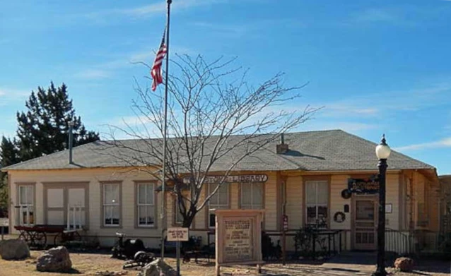
After the railroad closed, the former depot was donated by Southern Pacific to the City of Tombstone, and city leadership turned it into the first permanent location for our library. While Tombstone has had a library since 1885, with George Parsons as the first librarian, it was moved from place to place depending on the available facility. There were even periods when no location was available, so the library was closed. After the library was placed in the old depot, the city had a contest and invited local school children to name the building; the winning entry was The Reading Station, which our library is called today. In 1971 an old caboose and boxcar were delivered by truck to Tombstone and placed on short rails behind the old depot building to remind visitors of the rail service.
Guests visiting Tombstone can see part of the original right-of-way near Toughnut and 4th streets, where a few old railroad cars are on short rails behind the library building. The original rail grade can also be spotted behind the Lookout Lodge and Tombstone Grand Hotel at the edge of town, as shown in the image above.
References
This page was written using information from the following three sources.
Myrick, David, The Railroads of Southern Arizona: An Approach to Tombstone, The Journal of Arizona History, Vol 8, No 3 (Autumn 1967), pp 155-170. Found at: https://www.jstor.org/stable/41695428. Downloaded on Dec 31, 2019.
The map is based on the mining sign erected by the City of Tombstone near the entrance to the Goodenough Mine property. That data was verified with a topographical map of the Arizona Benson Quadrangle, published by the US Geological Service, George Otis Smith, Director, 1914.
Information about the depot building was found in Tombstone's Historic Locations, a booklet published by the Tombstone Restoration Commission in 2008 and available at several locations in Tombstone.
Location
The old depot and current library are located at the intersection of Toughnut and 4th Street.

